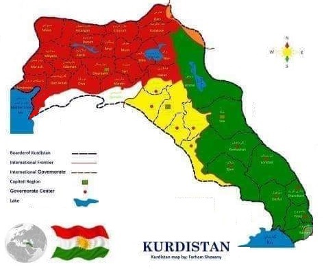
KURDISTAN's
MAPS
Burası öz be öz Kürd yurdudur
"Dünya üzerinde hiçbir şey sınırlardan daha tiksinti verici, daha aşağılık olamaz."
Herman Hesse
(Görkemli Dünya kitabından)
ÇOK DOĞRU!
İşgalci, İslamo-Faşist türk, arab & fars ilhakçıların, talancıların, sömürgecilerin kadim kürd ülkesi KÜRDİSTAN üzerinde yarattıkları SUNİ SINIRLAR insanlığın en büyük utancıdır.
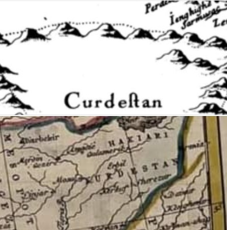
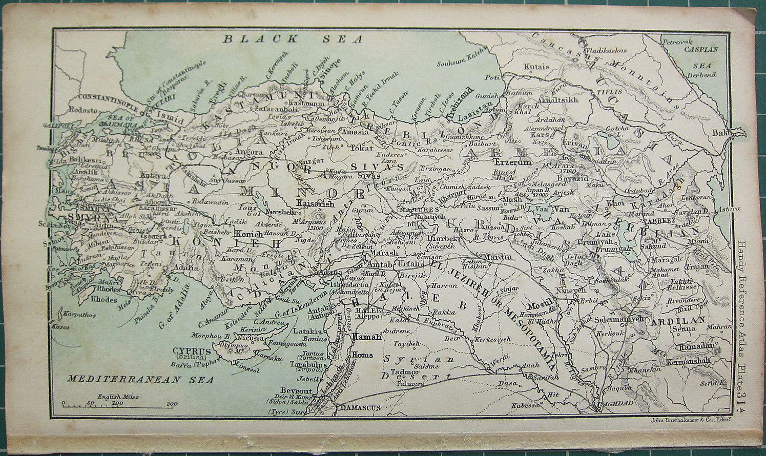
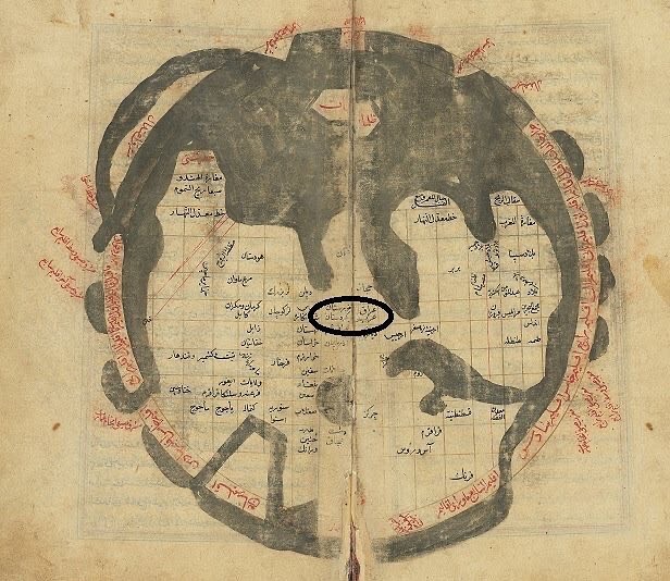
Kurdistan 1481
Here is Kurdistan's site from more than 500 years ago.
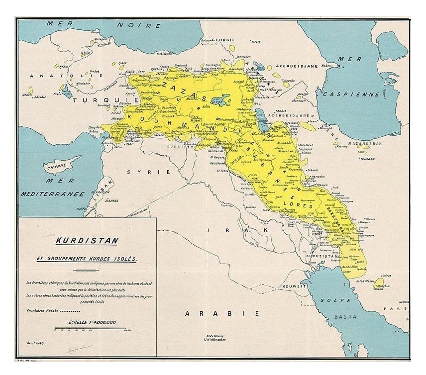
And also Shahrazor place (Governorates of Sulaymaniya and Kirkuk currently), Lorestan, Ardalan and Mukryan (Kurdish regions within the Iranian border today).
Kardukilerin bir köyüne vardık. Burası dağlar ve geçitlerle çevrili zor bir coğrafya.
Kardukiler bizi görür görmez kadın ve çocukları dağa gönderdiler.
Erkekler dağların tepesinde şarkı söyleyerek ansızın ordumuza saldırdılar. Ordumuza ok ve taş fırlattılar.
Bağımsız bir kabile olan Kardukiler, Pers Kralına düşmandılar. Kardukya coğrafyasında kaldığımız süre içerisinde cehennemi yaşadık ve büyük acılar çektik.
Ksenofon, Anabasis, M. Ö 400
“Yunanlı tarihçi Ksenofon’un kardukları, Strabo’nun gordiyaları, Polybious’un kurdiyaları, Plinius’un bahsettiği Corduenilerin ülkeleri bugün kürdlerin üzerinde yaşadıkları ve kendilerine ait olan topraklarıdır.”
Wilhelm Köhler - 1928
Hemde en azından onüç bin seneden beri!
Üç beş step çakalının birkaç yüzyıl önce açlıktan kaçarak buraya göçüyle köklü ve asli otantik bir halk olan kürd milleti'nin büyük anavatanı Kürdistan'ın demografik yapısıyla oynanarak
Kürdistan kirletilmeye ve bozulmaya çalışılıyor.
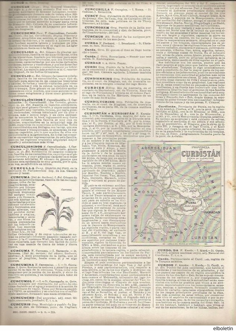
1892
Bo mezinkirine BITIKÎNE VIR!
KLICK HERE TO ENLARGE!
Büyütmek için BURAYA TIKLA!
Kurdistan map 1892 in FUL SIZE
Iraq was founded 1932
Turkey founded 1923
Syria founded 1945
Iran founded 1935
Kurdistan Karte aus 1892
Irak wurde 1932 gegründet
Türkei wurde 1923 gegründet
Syrien wurde 1945 gegründet
Iran wurde 1935 gegründet
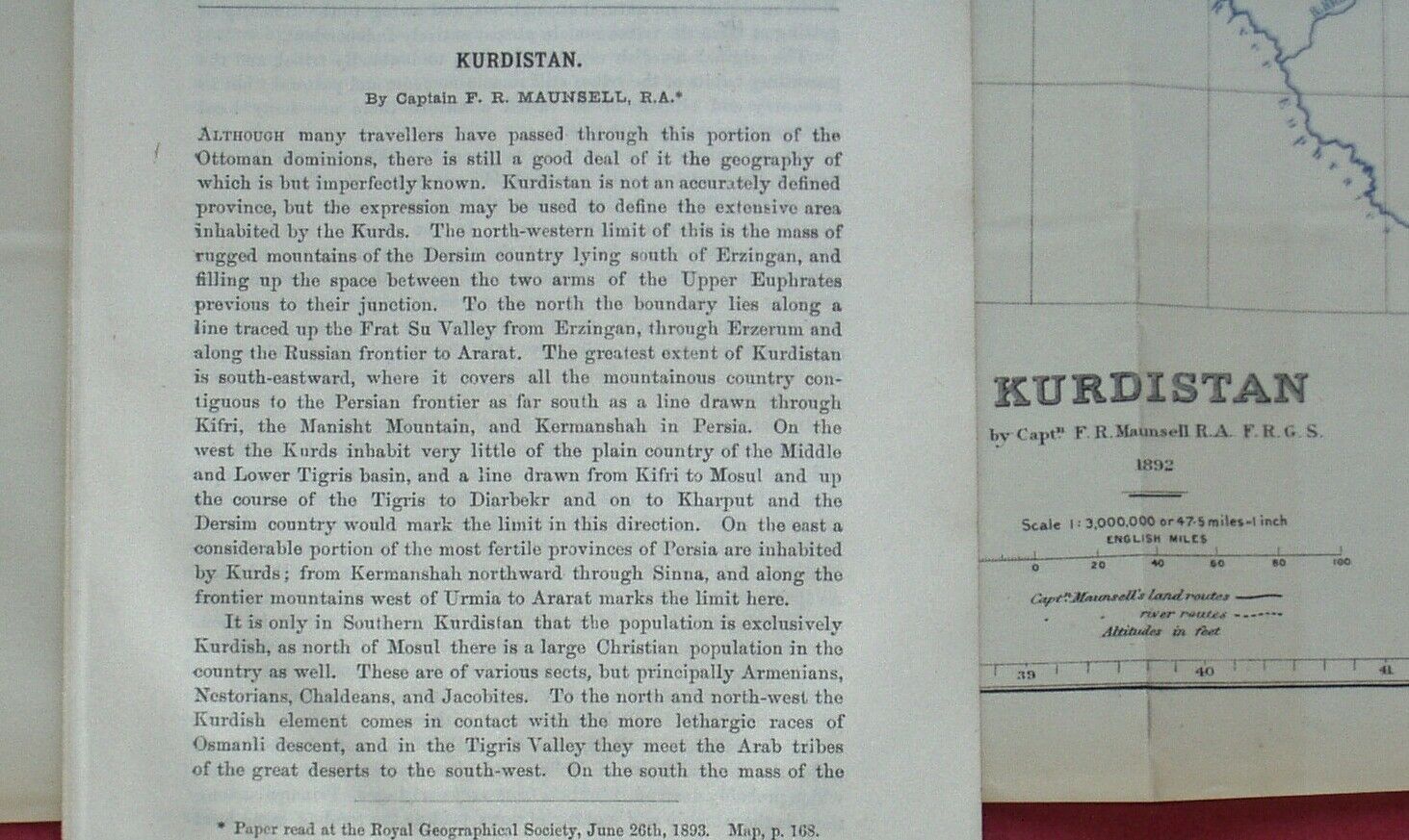
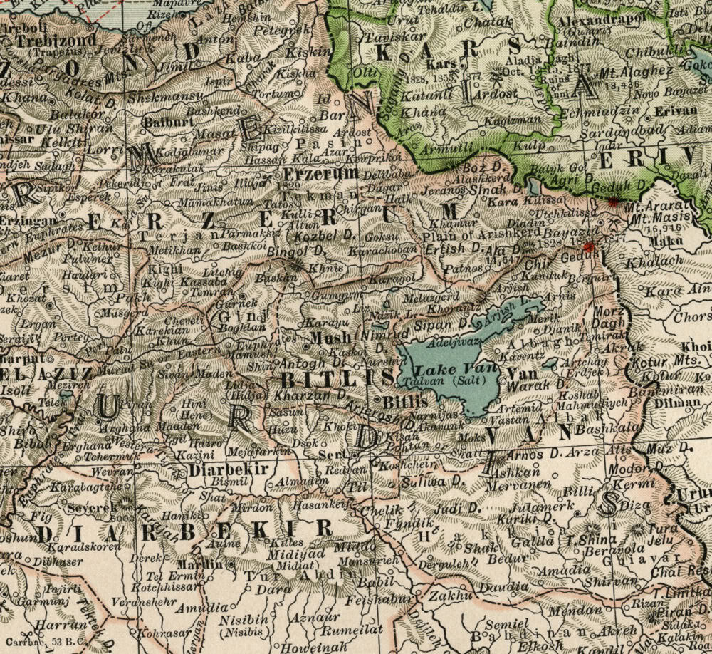
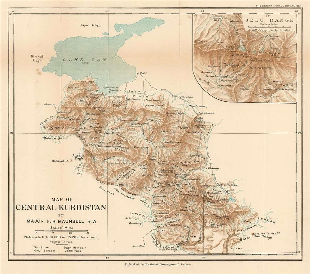
(Maunsell'in 1892 tarihinde hazırladığı Kürdistan'ın Fiziki Haritası. Bu harita, 1831 tarihinden itibaren aktif olarak yayın hayatına devam eden The Geographical Journal dergisinin 1894 yılı sayısında yayınlanmıştır.)
13 x 13.25 Uncirculated Color Map of Kurdistan by Capt, F.R. Maunsell R.A. Detailing land routes and river routes and altitudes in feet.. This map was folded once, then in thirds. Published by the Royal Geographical Society 1894. Kurdistan covers about 74,000 sq mi (191,660 km²), and its chief towns are Diyarbekir, Bitlis, and Van in Northern Kurdistan which is ockupied by Turkey now, Mosul, Erbil and Kikuk which is ockupied by Iraq now, and Kermanshan which is ockupied by Iran now. Lacin which is ockupied by Armenia and Azerbaijan now. The total area of Kurdistan is estimated at approximately 750,000 km². Others estimate as many as 100 million Kurds live in Kurdistan, which covers an area biger than France. The Kurdistan Province in Iran, Iraq, Syria and Armenia & Azerbaijan are included in the usual definition of Kurdistan which is the biggest part of Kurdistan and is occupied by the Islamo-Fascist Turkey today.
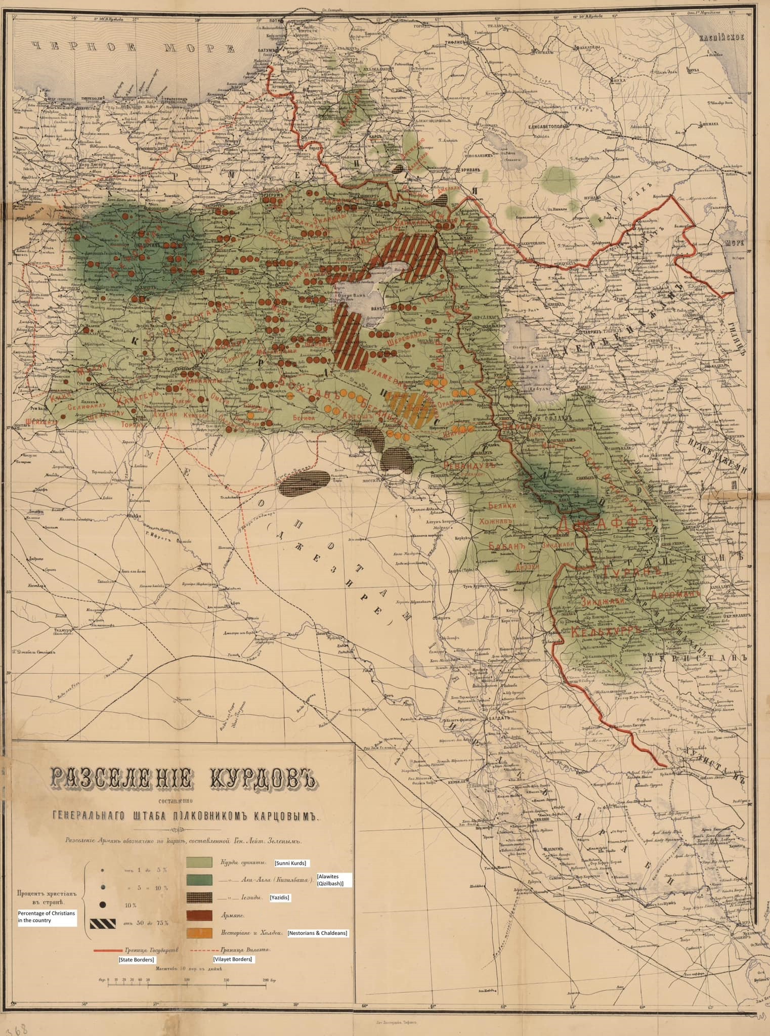
1896 Russian Map of KURDISTAN
‘Mervani Krallığı - Kürdistan’ ibareli harita…1130
Mervani Kürd Devleti 990-1100 yılları arasında Ahlat - Silvan - Diyarbakır - Urfa - Mardin vb bölgelerde egemenlik sağladı.
Devletin kurucusu Baz Ebu Abdullah El-Kurdi Hizan’ın bir köyünden (Durîye Mervan Bölgesi) olup yiğitliğiyle ün yaparak devlet kuracak güce ulaşmıştır.
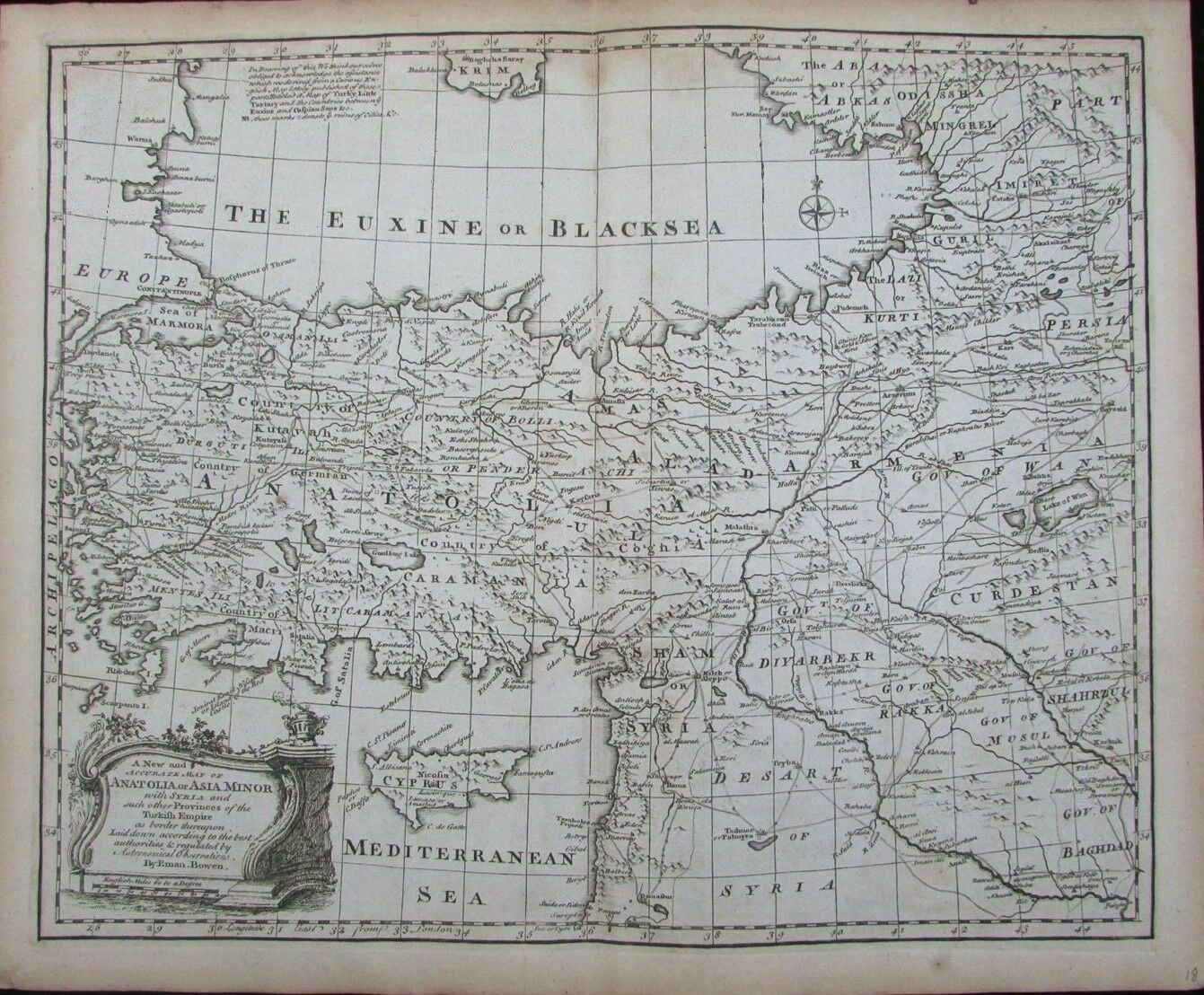
ANTIQUE BOWEN MAP: CURDISTAN (Diyarbekr) 1776
(KURDISTAN: Long before Turkey, Iran and Iraq)
''Kürdlerin tarihi vatanları Dicle Nehri'nin üst kesimleri ve Batı Asya'nın dağlık bölgesi olan Kürdistan'dır.
Eski kaynaklarda modern Kürdlerin ataları Karduchi'dir. Kürdler üç bin yıldan fazladır kendi topraklarında yaşamaktadırlar.''
S. Arutyunov, SSCB Bilimler Akademisi
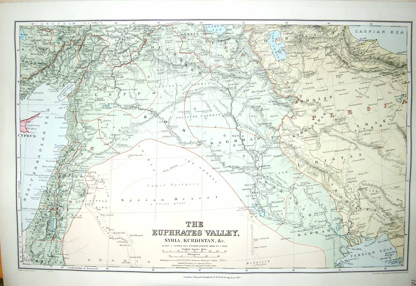
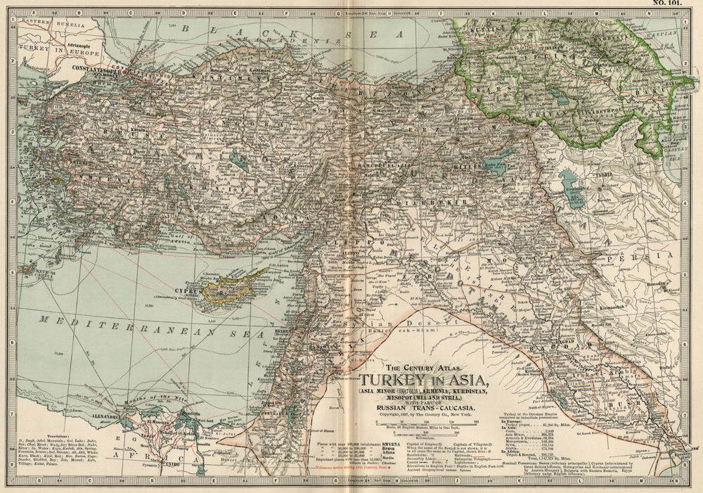
ASIA MINOR ~ HALEB KURDISTAN SMYRNA MESOPOTAMIA - 1904
KÜRDLERE KARŞI GERÇEK ANLAMDA ZULÜM KÜRDİSTAN'DA İSLAM FETİH GİRİŞİMLERİYLE BAŞLADI VE NAYLON ULUS TÜRKİYE KURULDUKTAN SONRA KATMERLEŞTİ
Halit bin Velid adındaki islam fetihçi komutasındaki arap orduları 7. yüzyılda Kürdistan'ın ve Acemistan'ın (İran'ın) sınırlarına dayandıklarında, kürdler için 1400 yıl uzun sürecek ve hala devam etmekte olan bir başaşağı gitme evresi başlamış oldu. Çünkü islam siyasi ideolojisnin fetihçi ve yokedici karektreri gereği, fethedilen bütün ülke ve halkların dili ve kültürü din-müslümanlık yoluyla araplaştırılıyordu.
Kürdistan islam orduları tarafından bir defada işgal edilemedi. İslam ordularının Kürdistan'ı istila ve işgali uzun yüzyıllar süren zorlu dönemlerden sonra gerçekleşti.
Bundan dolayı, islamın merkez yayılma alanı olan Ortadoğu'daki bütün ülkeler ve milletler tam araplaştırıldı. Kürdistan, Suriye, Mısır ve diğer Kuzey Afrika ülkelerinin tümü dil ve kültür bakımından islam yolula araplaştırıldı.
1639'da Kasr-ı Şirin Antlaşması ile iki müslüman devlet, osmanlı ve safevi müslüman devletleri arasında Kürdistan iki parçaya bölündü. Ondan sonraki ikinci bölünme ise 1828 yılında Türkmençayı denilen Kacarlar (acem İran) ile Rusya arasındaki bir anlaşmayla bu defa Doğu Kürdistan'ın bir kısmı Rusya'ya bırakılarak üç parçalı derin bir bölünme gerçekleşti kürd halkı üzerinde.
Bu iki büyük lanetli bölüşüm ve paylaşım antlaşmaları akabinde kürdler çok büyük ve ciddi bir toplumsal parçalanma yaşadı.
Kürdistan'ın 6 parçaya bölünmesinin lanetli tarihi ise, Avrupa'nın süper güç devletleri olan İngilte ve Fransa tarafından yaratılan naylon türk ulusu, naylon Suriye-arap ulusu, naylon Irak-arap ulusu ile 1923 yılında gerçekleşti ve bu bölünme kürd halkını canevinden vurdu.
Ama kalıcı ve ebedi bir bölünme olmaması için kürdler Kürdistan'ın her parçasında bu bölünmüşlüğe karşı büyük bir mücadele veriyordur.
İnsanlık mazlum kürdlerden yanadır ve tarih istilacı ve işgalci türk, arap ve fars müslüman devletleri kürd halkına karşı yaptıkları affedilmez büyük insanlık suçlarından dolayı lanetlemiştir.
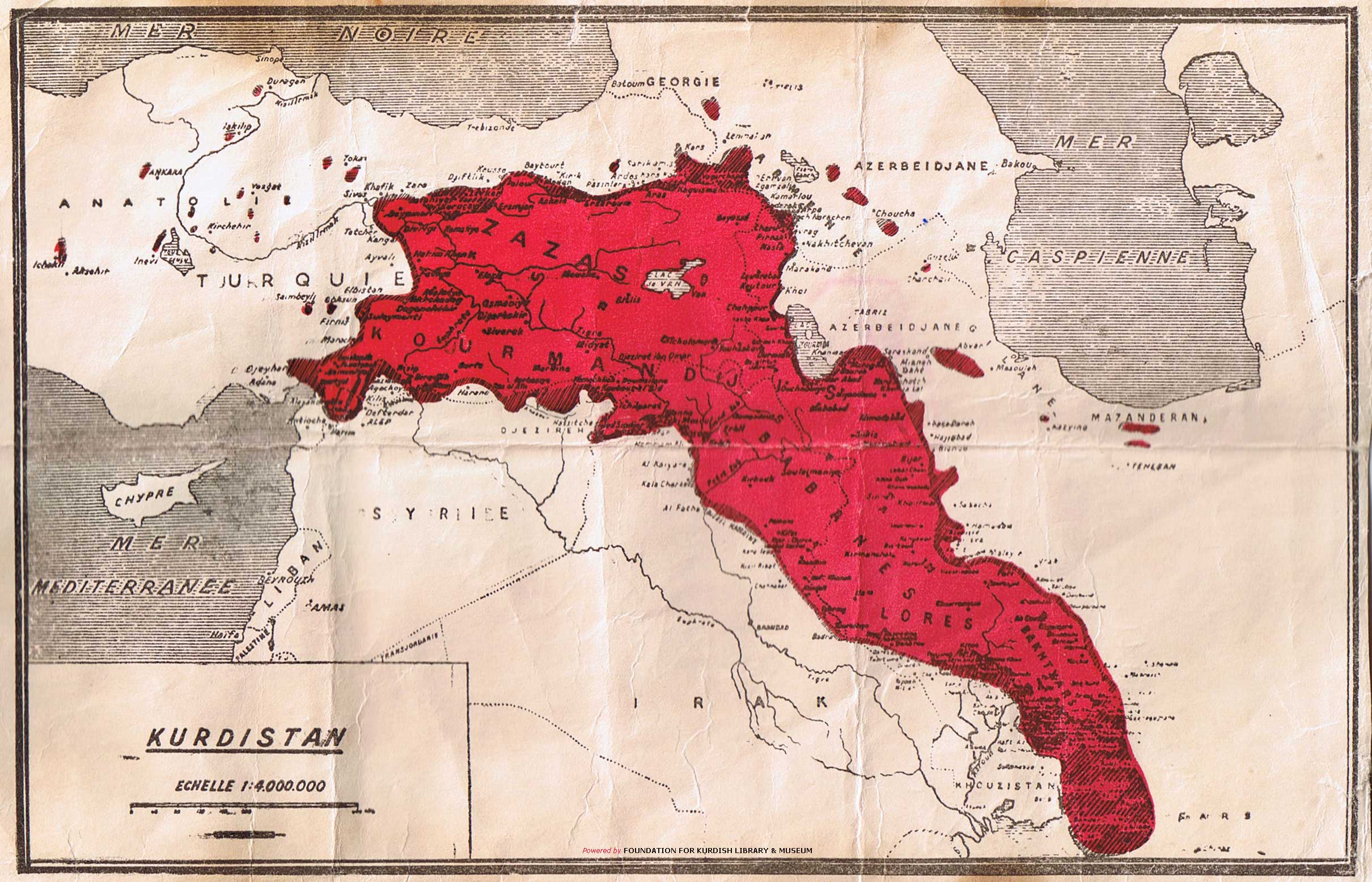
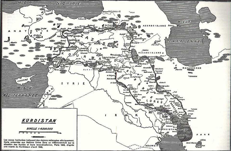
THE MAP OF KURDISH DELEGATION 1956
"Kürd aşiretlerinin de yüzyıllardır yaşadığı bu coğrafya Basra Denizi’ne kadar uzanır. Bu Kürd aşiretlerinin ataları olan Karduklar (Carduchi) da, bu bölgede 2300 senedir sürekli ve sağlam bir şekilde hep var olmuşlardır."
Crosby H. Wheeler, 1876

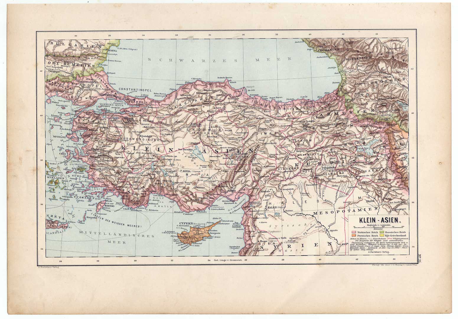
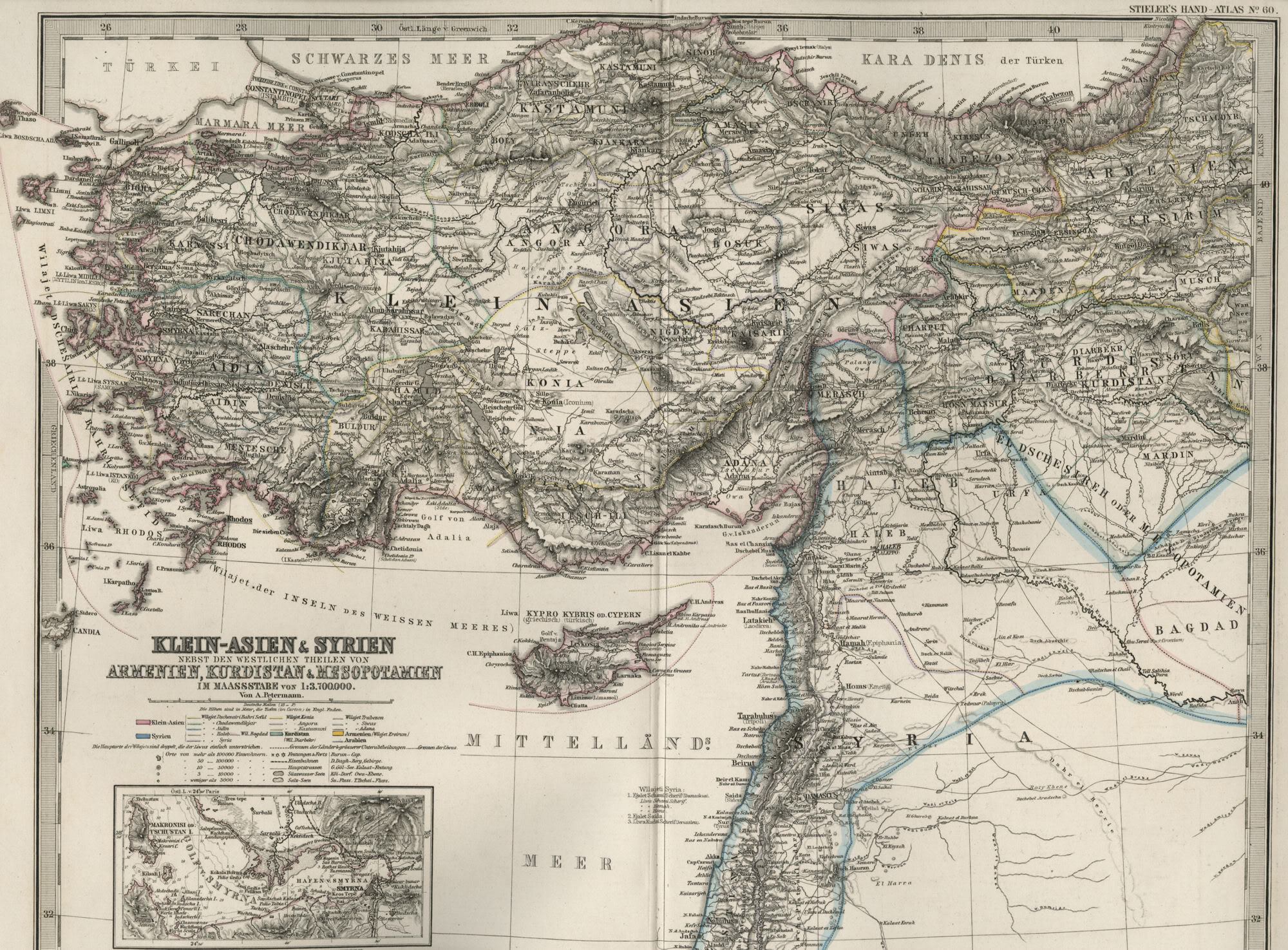
Klein - Asien - Kurdistan: Original Lithographie aus Hartleben´s Verlag, Wien, Pest, Leipzig, 1889.
Kartogr. Litho. Anstalt von G. Freytag & Berndt, Wien. Blattgröße ca. 28 x 40 cm.
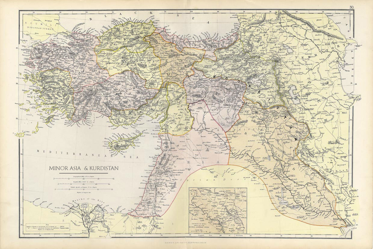
1886 Blackie-s Atlas Cyprus Kurdistan Mosul
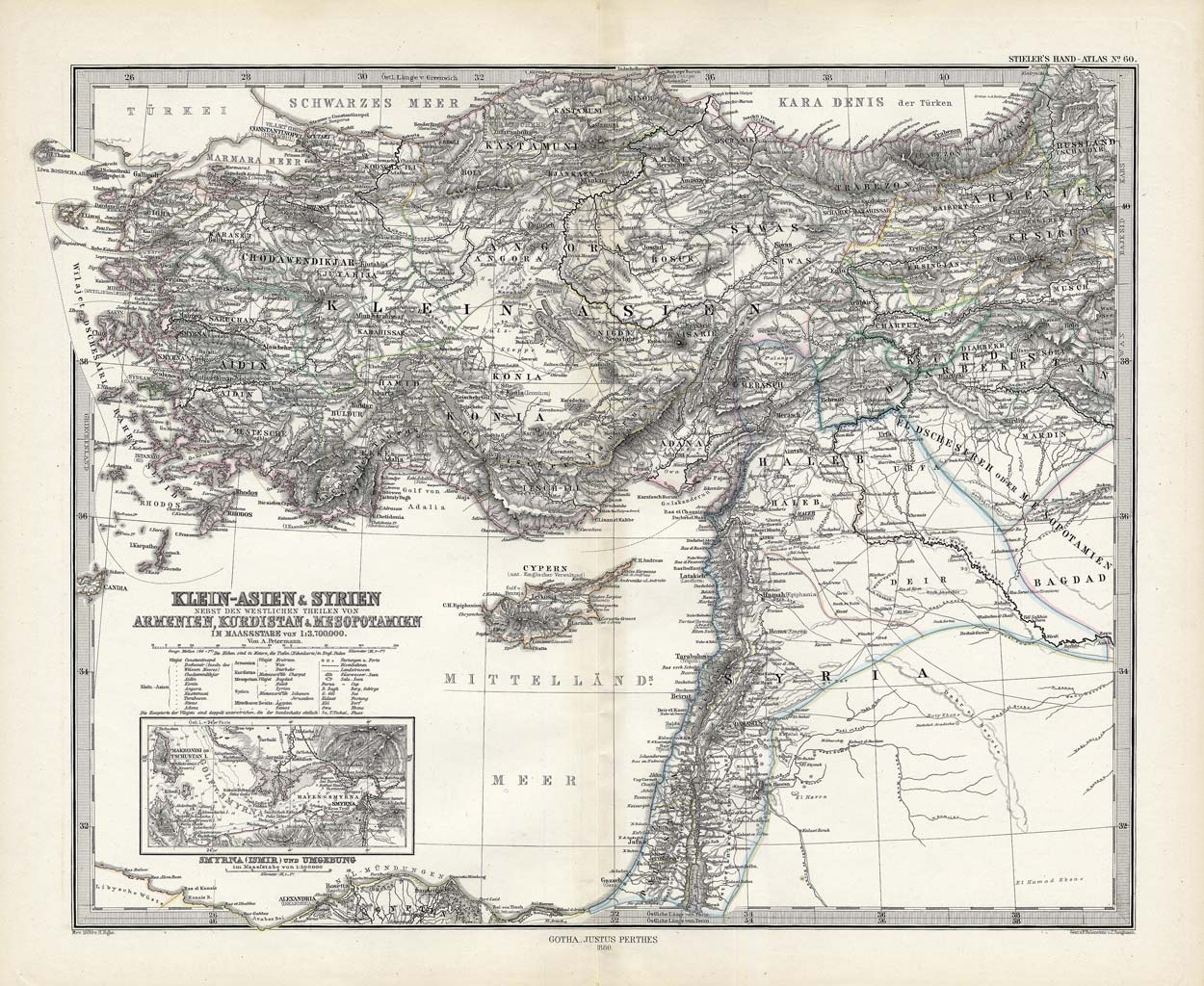
Stieler1881-60
|
Sözüm ona türk meclisinde
Geography
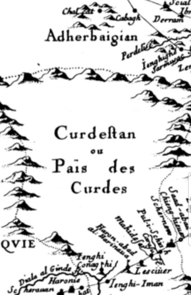
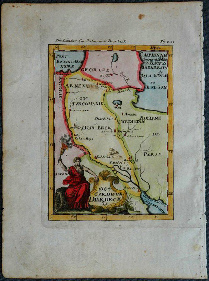
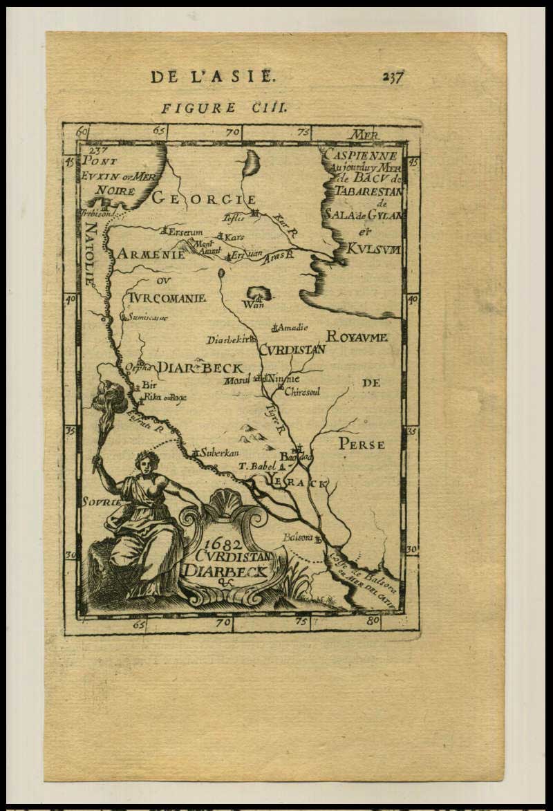
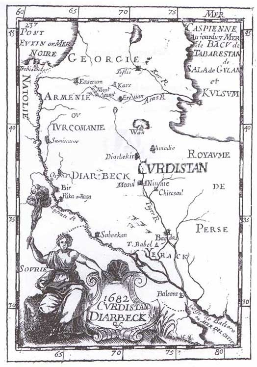
and Perceptions of Kurdistan 1682 YILINA AİT BİR KÜRDİSTAN (CVRDISTAN 1682) HARİTASINDA 'Turcomania' yani ''türk''men SÖZÜ İLE İLGİLİ ÖNEMLİ NOT: Sürekli türk milliyetçileri ve ırkçıları 'türkmenler ve türkmenlerin hakları' diye çığırtıyorlar. Önce bu türkmen sözü nedir ve türkmenler kimdir bir ona bakalım. Türklerin de artık sık sık belirtiği gibi kürdler Kürdistan'da binyıllardır bulunmaktadır. Türkler Kürdistan'a daha yeni geldi sayılır. Türklerin bölgeye gelişleriyle bir kısım yerli halk türklerin yerleşim vb sorunlarında türklere yardımda bulundular. Zamanla bunlar türklerle beraber olarak kalmaya başladılar. Bunun için kürdçe'de bunlara 'türklerle beraber kalanlar' anlamına gelen 'turkman' denmeye başlandı. 'MAN' kürdçede kaldı demektir. Yani türklerle kaldı. Sonra türkler devlet kurduklarında bunlar türklerin devletinde görev alan bir kesim olarak Kürdistan'da nüfus olarak giderek büyüyen özel bir katman oluşturdular. Türkmenlerin dilinin önemli bir kesiimin hala kürdçe olduğu, türkmenlerin sosyal-siyasal ve kültürel ruhi şekilleniş bakımından hala kürdlere daha çok benzediğinin en büyük sebebi de budur. Kürdistan'da yarı türkçe ve yarı kürdçe konuşan bu kesimin yoğunlukla yaşadıkları bölge bazı haritalarda da belirtilmiştir. İşte yukarıda gördüğümüz 1682 yılında latin dilinde 'CVRDISTAN' olarak etiketlenen bu KÜRDİSTAN HARİTASI'nda görüldüğü gibi turkomanların, türk kalanların yani türkmenlarin yoğunlukta yaşadıkları Kürdistan'ın Serhed bölgesindeki haritada adları geçmektedir. İşte türkmenlerin bütün hikayesi budur: ''Hez ederem''.. |
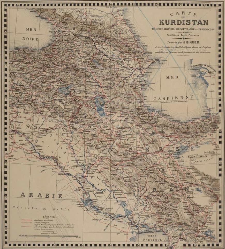
Henry Binder - 1887
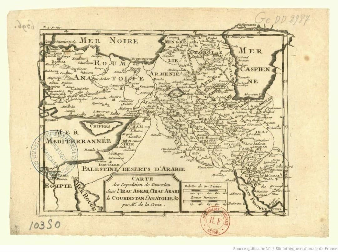
CURDISTAN 1787
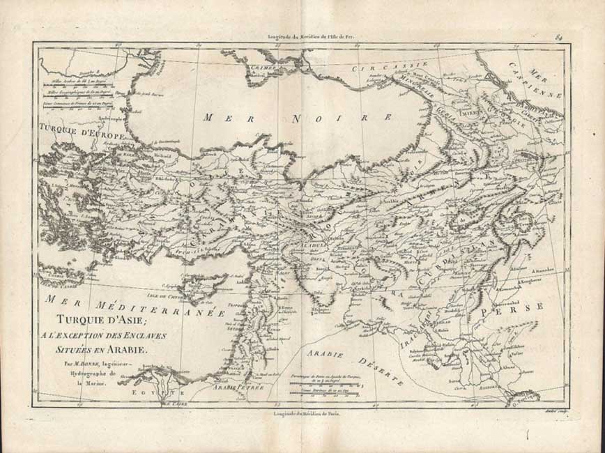
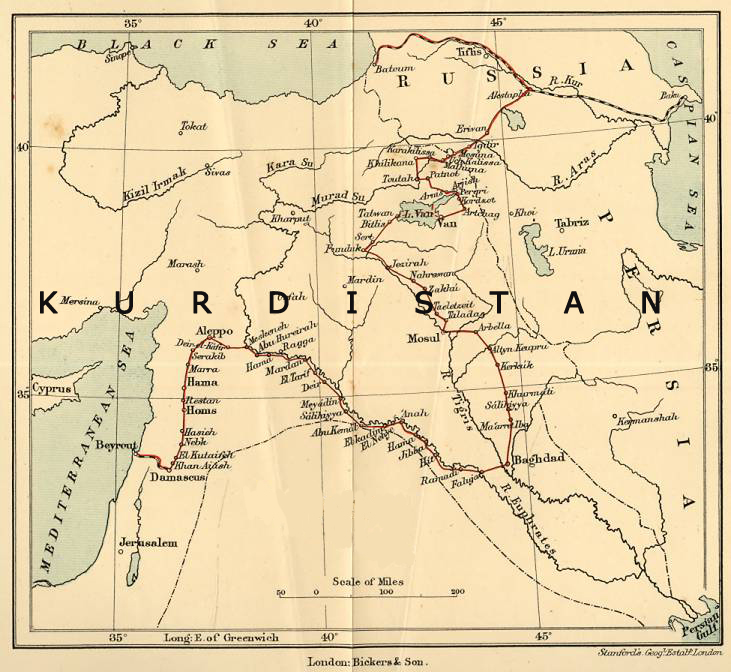
Kurdistan's Proninces 1904:
DIYARBEKR
KERMANSHAN
LÛRISTAN
ERDELAN
Orientalische Kleinasien Kurdistan Armenien Historische Landkarten 1897
1876 Large, Dated, Hand-Colored KURDISTAN Map
& Asia Minor & Syria
including, Armenia; Aidin; Mughla; Konia; Angora; Siwas; Kastamuni; Bagdad; Cyprus and more.
This is a 130+ Year-Old Map--NOT a Reproduction, Most legends and place names are in the GERMAN language.
1600'lü yıllarda çizilmiş ve Timurlenk zamanı 1300'leri yansıtan bir harita...
Kurdistan, Ermenistan vs...
Fransız Milli Kütüphanesi

Denna karta har anor från Edward von Nolde, som reste till Mellanöstern, #Kurdistan och Armenien mellan 1886 och 1892
1900
Kurdistan's Provinces
KURDISTAN MAP (1897)
KURDISTAN MAP (1897)
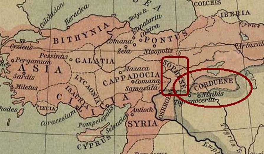
CORDUENE (GORDION) - Where does the name Kurd come from?
The word kurti is from sumerian and means: "kur" means mountain/hill and "ti" means from. So it means the people from the mountains/hills. This word kurti is the oldest known word which describes the kurds from 3000 BC.
In 1923, English Orientalist Sir Godfrey Rolles Driver published a scientific research article "The Name Kurd and Its Philological Connexions". Driver, who was also an Assyriologist had tried to find who was the Qurti who had lived around the lake Van and with whom Assyrian warrior Tiglath-Pileser "I had fought" in ~1050 BC.
Driver also tried to find the connection between Qurti and "the land of Karda" [Kardaka] text which was written on a Sumerian clay-tablet, of the third millennium B.C. Sumerians called the area around Lake Van a land of Karda. Driver examined the philological variations of Karda in different languages, such as Cordueni, Gordyeni, Kordyoui, Karduchi, Kardueni, Qardu, Kardaye, Qardawaye. He realized that all these names were actually the conversions of "Karda" in different languages. Also, he managed to connect all these names to the same area, Lake Van in contemporary Kurdistan.
Sumerian called it the land of "Karda" (3000 BC)
Tiglath-Pileser I had fought against "Qurti" from the same area (1050 BC)
Greek historian Xenophon called people who lived around Lake Van a "Karduchi" people. He called the area a Corduene (400 BC)
Artakhshir, the founder of the Persian Sassanid dynasty fought against the "Madrig the King of Kurdan" in same area (226 AD)
Driver reaches a conclusion that the term Kurd wasn't used differently by different nations and roots of modern Kurds can be found from the ancient Corduene region. He also said that the root of ancient Kurds are very likely in the land of Kardas.
__________________________
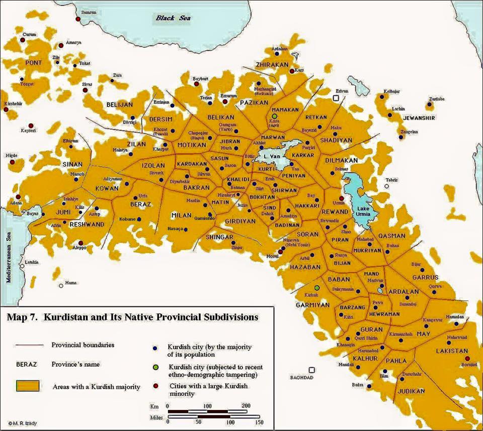
Kürdistan’ın antik çağda bazı bölgeleri ve günümüzde buna karşılık gelen modern isimleri;
Corduene veya Gordyene (Siirt, Bitlis, Şırnak)
Sophene (Diyarbakır)
Zabdicene or Bezabde (Gozarto Cizre)
Basenia (Bazîd)
Moxoene (Muş)
Nephercerta (Meyafarqin)
Artemita (Van)
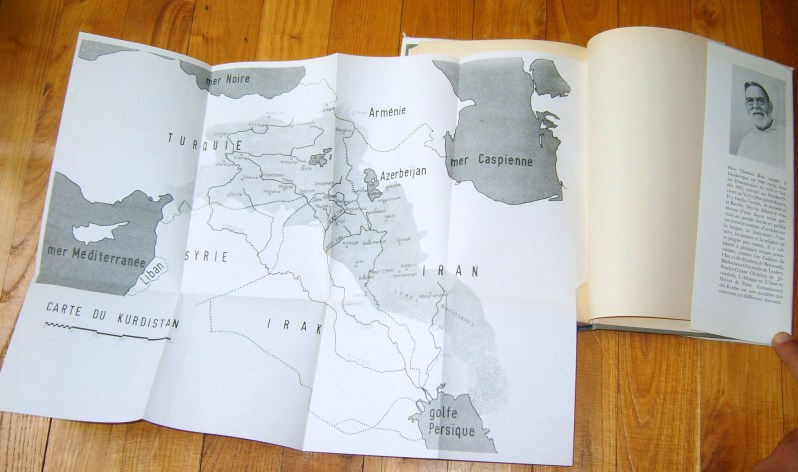
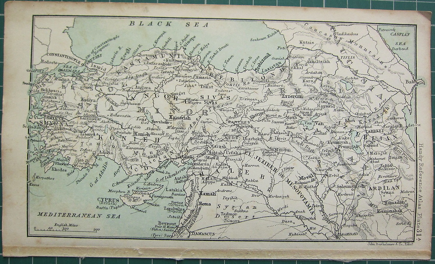
KURDISTAN MAP (Thomas Bois, CONNAISSANCE DES KURDES 1965)
1861
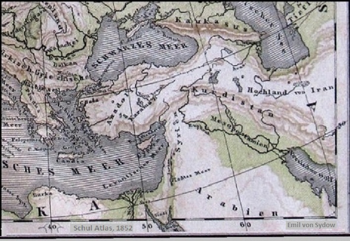
1852
“Kurdistan, Dicle’yi geçince Tebriz’e kadar hemen hemen eşit şekilde eşit şekilde dağ ve ovadır. Dağlar mazı dolu meşelerle kaplıdır.
Ülkenin göze çarpan ürünleri mazı ve tütündür.”
Jean Baptiste Tavernier (1605-1689)
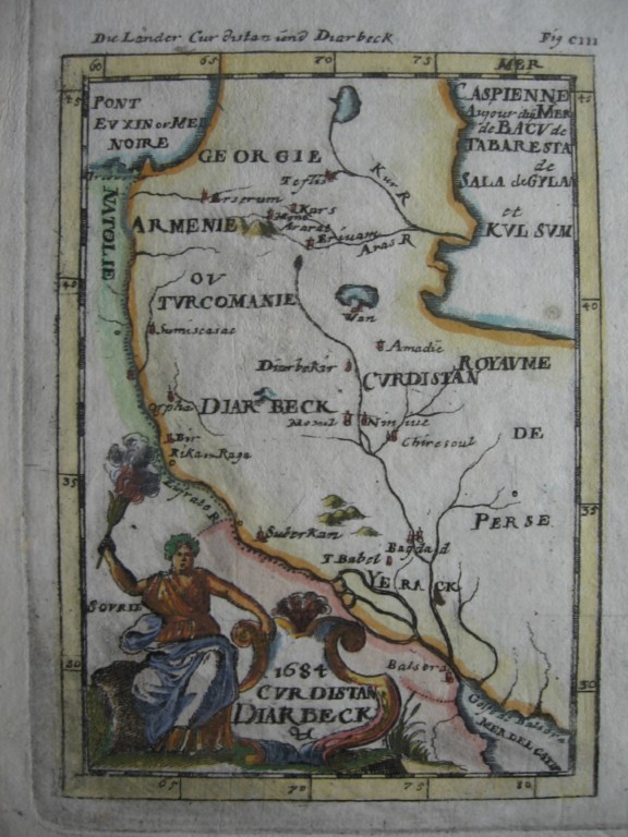
An
ORIGINAL 17th century map (1684)
******
CURDISTAN DIARBECK
by
Alain
Manesson Mallet
German issue
Central Kurdistan

Wîlayet El Kerkûk Fî El Memleket-ul Kurdistan Fî El Memleket-ul Usmaniye: The map from 1893 - Ottoman era showing the Kurdish city Kirkuk = in the Autonom KURDISTAN Province
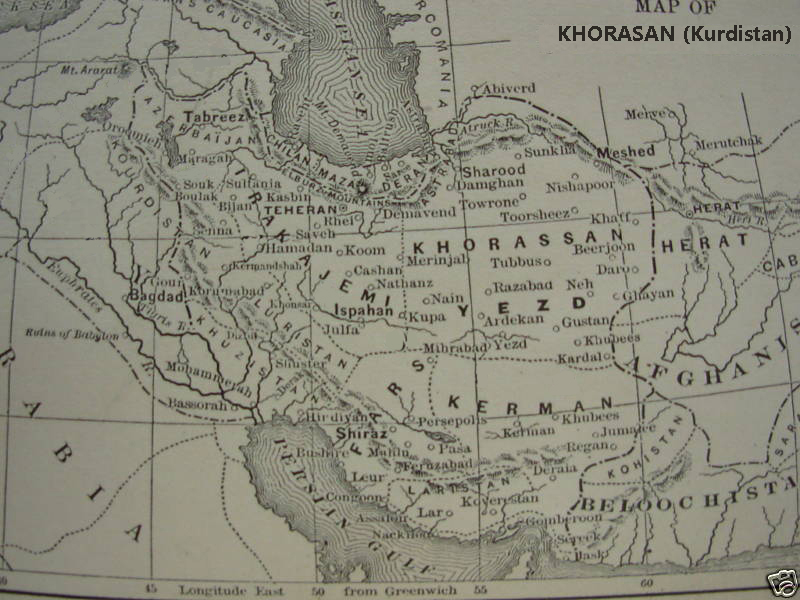
Map of Khorasan (Kurdistan)
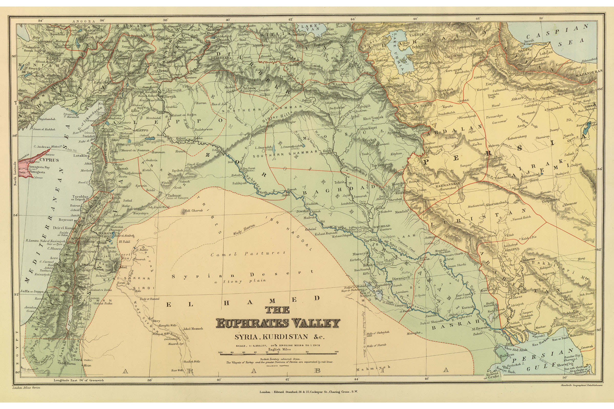
1856 MAP of KURDISTAN SYRIA IRAQ CYPRUS ARMENIA


1917
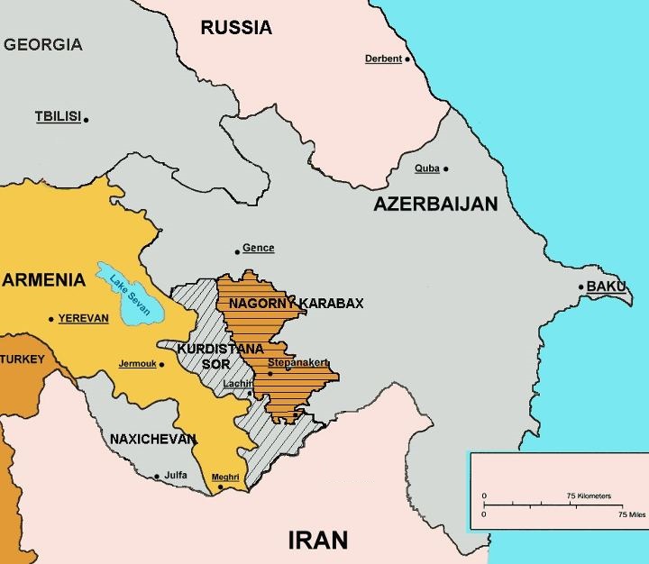
Kurdistana Sor, LACHIN
1862
1869
1904
1900
KÜRD & KÜRDİSTAN
Kürd/kürd ismi çok eski tarihlerden beri süregelen bir isimdir. Medeniyetin en eski tarihi kaynakları olan Mezopotamya tarihi kaynakları 'KUR' (sümerce'de dağ) isminden kaynaklı bu ismin sümer kitabeleri olan en eski yazılı tarihi vesikalara işaret ederler. Sümerler kürdleri 'KURTİ' olarak adlandırmıştır. Kur = Dağ, Ti = aidiyet anlamını veriyor. Yani Dağ Halkı anlamına gelmektedir. Kürdlerin yaşamış olduğu coğrafyanın yapısı ve çok eskiden coğrafyaya göre halklara isim verilmesi geleneği Kürtlerle ülkeleri arasındaki bağı da kurmuştur. Ama şu da bilinmelidir ki Proto-Kavim olan kürdlerin en ilk toprağı süren ve en ilk ekin eken bir kavim olduğu ve bugün üzerinde yaşadıkları coğrafyada, en az 10 bin yıl önce bulunduklarını artık su götürmez bir gerçektir. 1 - 2500 yıl önce Grek kaynaklarında kürdlerin yurdunun adı ''Kardaka/Kardukya'', daha sonraları ''Kordienne/Gordienne/Kurdienne'' (Kürd Ülkesi) olarak geçmiştir. 2 - Kaşgarlı Mahmut tarafından 1072-1074 yıllarında yazılan ve içinde kendi çizimleri olan haritalar bulunan Divân-u lügati't-türk’teki bir haritada 'Kürdistan, Erdu'l-Ekrad' (Kürdistan - Kürdlerin Toprağı, Yurdu) olarak belirlenmiş ve böyle isimlendirilmiştir. 3 - Kürdistan, Ermenice; Korchayk, Latince; Gordyene, Yunanca; Kordyene, Batı dillerinde telaffuz farkıyla Kurdistan olarak adlandırılır. 4 - Ermeni tarihçi Urfalı Mateos’un 1032 tarihli Rumca bir yazışmada Mervani eğemenliğindeki ülkenin adının 'Krtasdan' (Kurdistan) olarak belirlendiğini söyler. 5 - Bugünkü haliyle Kürdistan ismi ilk kez, kendileri de köken olarak kürd olan selçukluların sultanı Sancar Beg’in (ö. 1157) merkezi Hemedan kentine yakın Bahar kenti olan ve bugün İran devleti'nin hala aynı adla bir eyaleti olan ‘Kürdistan Eyaleti’ için kullanılmıştı. Bey kelimesi türkçe olmayıp, kürdçe bir kelimedir ve hala günümüzde bile binlerce yıllık en eski formuyla 'beg' olarak telafüz edilir. 6 - 1514 Çaldıran savaşından sonra kürdler Osmanlı yönetimi içinde özerk statü kazandı. İran’dan Irak’a, Suriye’den Anadolu’ya uzanan geniş Kürdistan coğrafyasının önemli bir bölümüne 28 Kürd beyine (Umera-i Ekrad) verilen ve özerklik anlamına gelen değişik imtiyazlar karşılığında Osmanlı Devleti’ne bağlı kaldılar. Kürd özerk yönetimlerinin elindeki bu geniş coğrafyanın adı resmi belgelerde ‘Kürdistan” olarak geçmektedir. 7 - Osmanlı padişahları elbette 'Kürdistan ülkesi' diye İTİRAFLARDA bulunmuşlardır. Bu itiraflardan biri, Fransa ile Almanya arasında 1536 yılında çıkan savaşta Fransa Kralı I. François’in esir düşmesi üzerine Kanuni Süleyman’ın Germen Kralına yazdığı mektupta, osmanlı tarafından işgal edilmiş ülkeleri sayarken, “Ben ki (…) Kürdistan’ın…” ifadesini kullanmıştır. 8 - Osmanlı Sultanı I. Ahmed, 1604 tarihli fermanında ‘Umum Kürdistan’ terimini kullanılmıştır. 9 - 17. Yüzyılda Evliya Çelebi seyahatnamesinde Kürdistan’ı “Büyük ülkedir. Bir ucu Erzurum, Van diyarlarından Hakkâri, Cizre, İmadiye, Musul, Şehrizor, Harir, Erdelan, Derne, Derteng’i de içine alarak BASRA KÖRFEZİNE KADAR yetmiş konak mesafe sayılır. Arap Irak’ı ile Osmanlı arasında bu yüksek dağlar içinde altı bin adet Kürd aşiret ve kabilesi güçlü bir sed olmasaydı acem (fars) kavmi için Anadolu’yu istila etmek çok kolay olurdu. (…)'' demektedir. 10 - Padişah Abdulmecid döneminde yayımlanan fermanda “Kürdistan eyaletinin teşkili hakkındaki Sedaret makamının 20 Cemaziyelevvel 1263 (1846) tarihinde idaresi istisâl edilmiştir” denerek, ‘Kürdistan Eyaleti kurulur. 14 Aralık 1847 tarihli Takvim-i Vekayi’de (O dönemin resmi gazetesi) yayınlanan fermana göre ''Kürdistan Eyaleti, Diyarbekir Eyaleti, Wan, Muş ve Hekkari sancakları ile Cizre, Botan ve Mardin kazaları''nı kapsıyordu. 11 - Şemseddin Sami’nin 1889’da yayımlanan eseri Kamusu’l-Alam’da ‘Anadolu’ maddesinde, bölgenin ''güneydoğu'' sınırını Kürdistan olarak belirtmiştir. 12 - 1890’da bastırılarak, devletin askeri ve sivil okullarında okutulan Coğrafya-i Umumi’de (yazarı Yenişehirli Ahmed Cemal), Osmanlı ülkesini önce ‘Avrupa-yi Osmani’ ve ‘Asya-yi Osmani’ diye ikiye; Asya-yi Osmani kısmını da altı bölgeye ayrıyordu: 1) Anadolu, 2) Adalar, 3) Kürdistan, 4) Irak, 5) Suriye ve Filistin, 6) Hicaz ve Yemen. 13 - İttihatçıların Dahiliye Nazırı Mehmed Ali Bey’in Hariciye Nazırı Ferid Paşaya gönderdiği 13-14 Nisan 1335/1919 tarihli tezkerede ''Kürdistan'' ve ''Kürd'' kelimeleri fazlasıyla yer alıyordu. 14 -Mustafa Kemal’in, Kürd aşiret reislerine çektiği telgraflarda, Sovyet Rusya Dışişleri Komiseri Çiçerin’e yazdığı mektupta, bazı Meclis konuşmalarında ‘Kürdistan’ dediği, Birinci Meclis’in Doğu’dan gelen üyelerine ‘Kürdistan mebusu’ dendiği bilinmektedir. |

“Kürdistan toprakları on altı şehri (bölgeyi) kapsar. Kürdistan, Fars Irak’ı, Huzistan, Azerbaycan ve Diyarbekir tarafından çevrilmiştir. “
Tarihçi Hamdullah el-Müstevfî (1281-1349) “Nüzhet’ül Kulûb” Leyden, 1919, s. 34-54-78
Osmanlı şair ve tarihçilerinden aslen yunanli Gelibolulu Mustafa Ali’nin ‘Dünya Haritası’ında’ yer alan ‘Kurdistan’
1541-1600 yılları arasında yaşayan Mustafa Efendi’nin en kapsamlı eseri ‘Künhü’l-ahbâr’dır.
Çok sayıda minyatürü de bulunmaktadır.

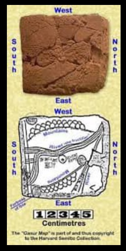
Dünyanın en eski haritası Nipur, Mezopotamya

Kurdistan map in the book about the barbarian Timur, printed 1722 in London

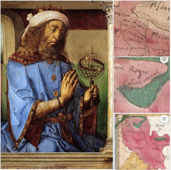
Klaudios Ptolemaios yani Batlamyus atlasını çizen kişi 90 yılında Misir İskenderiyesi'nde doğuyor..
O süreçte yaptığı haritalarda 'Kürd dağlari', 'Media', 'Ruha', Kurdistan coğrafyasının sınırlarını çizmiş..


Toroslardan Zagroslara Kürd Toprakları... İskenderiyeli Yunan matematikçi ve coğrafyacı.
Klaudios Ptolemaios (Batlamyus) MS.2.Yüzyılda kürdlerden söz etmiştir.
Batlamyus Atlası Dünya'nın ilk atlası olarak bilinmektedir. ''Gordionoros'', ''Kürd Dağları'', ''Kürd Ülkesi''.
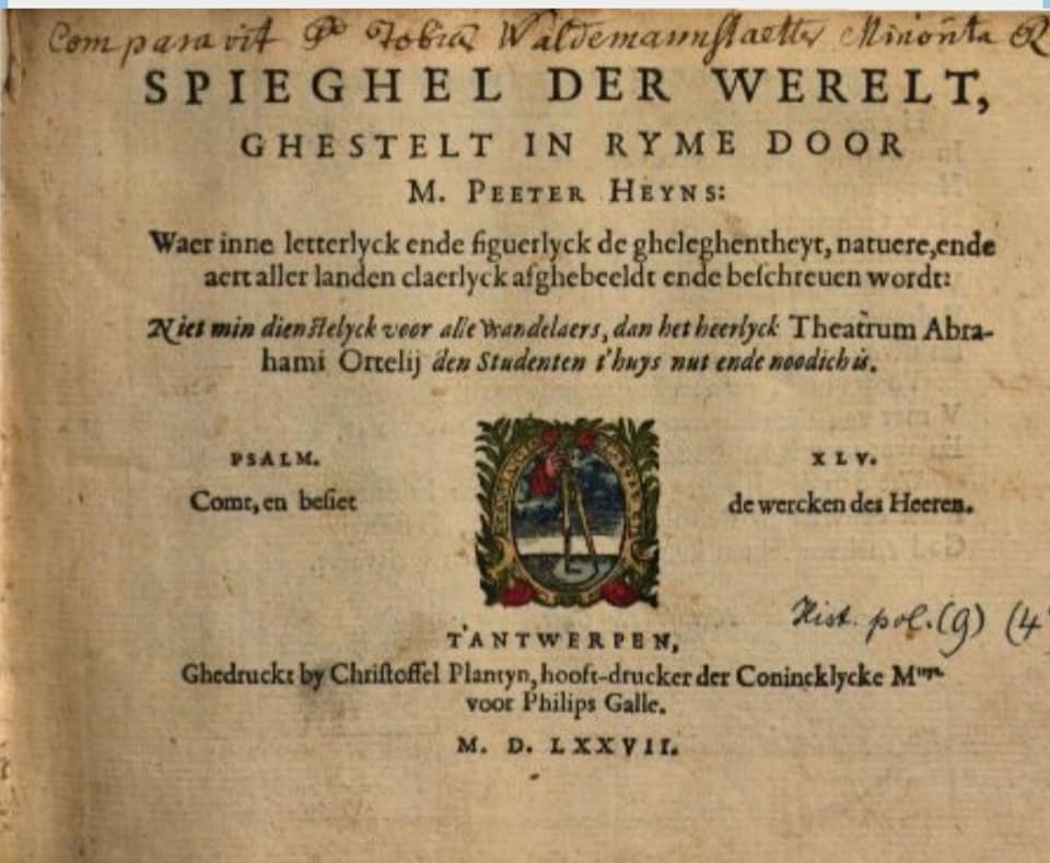
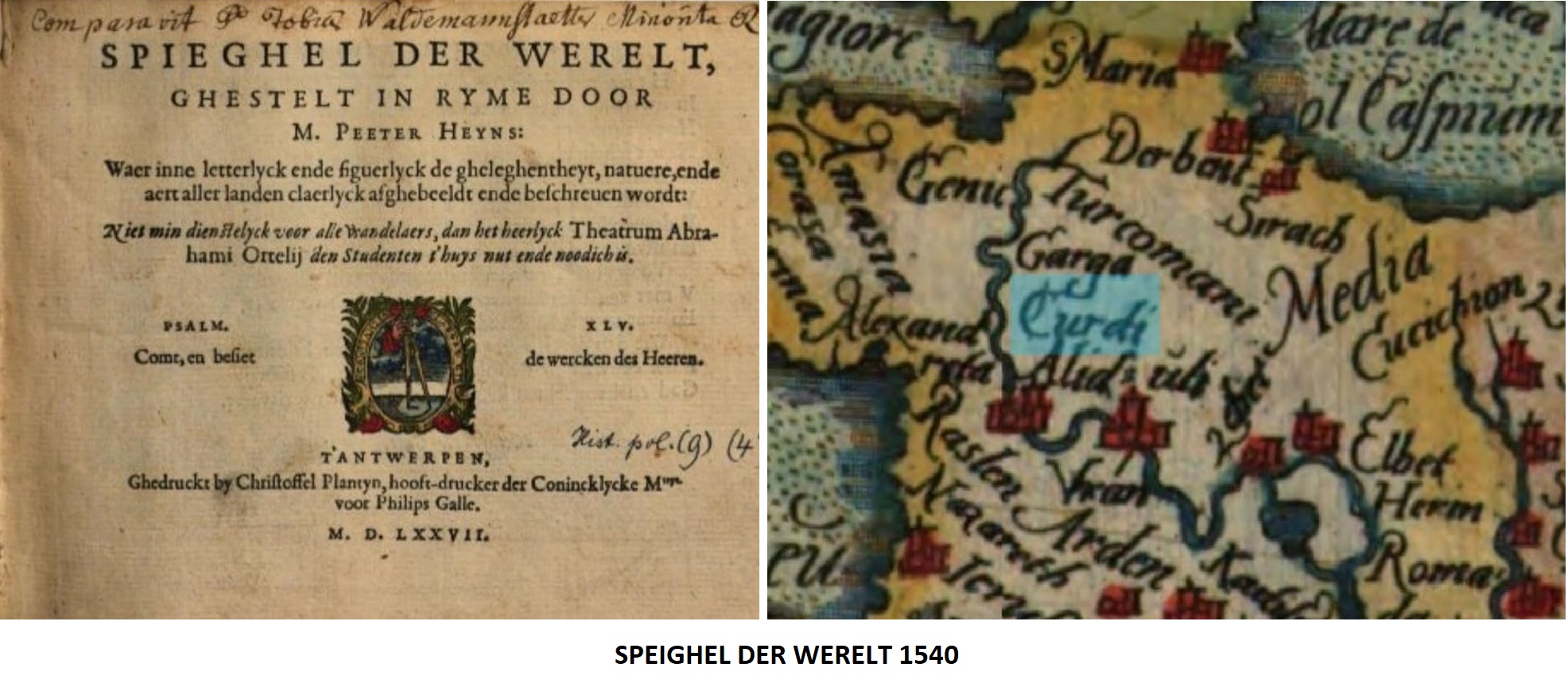
SPEIGHEL DER WERELT 1540
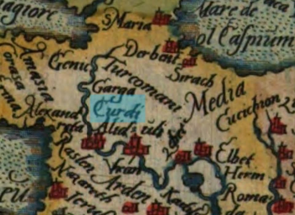
Curdi

Gordeai - Gordena Kurdistan Map 1545
DÜNYANIN İLK HARİTASI
Dünyanın ilk haritası

Al bunları münasib bir yerine sok işgalci-ırkçı kemalist-faşist devşirik kırması İlber Oltaylı.
Kürdler tarih sahnesindeyken türkün esamesi bile yoktu..
''Harita çizerek''miş... Dünyanın en ilk haritasında da varız OĞLUM!
KÜRD DAĞLARI GORDION(OROS)
MS ilk yüz yılda İskenderiye'de yaşamış yunan astronom, matematikçi ve coğrafyacısı Claudios Ptolemaios kendi yazdığı dünyanın bilinen en ilk atlası olan coğrafya kitabında (GEOGRAFIA) kürd dağları olan Toros ve Zagrosları ''kürdlerin dağı'' Gordion(oros) olarak zikretmiştir.
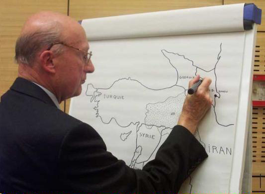
The French diplomat Bernard Dorin drawing Kurdistan's map
THE MAP OF KURDISH DELEGATION 1956
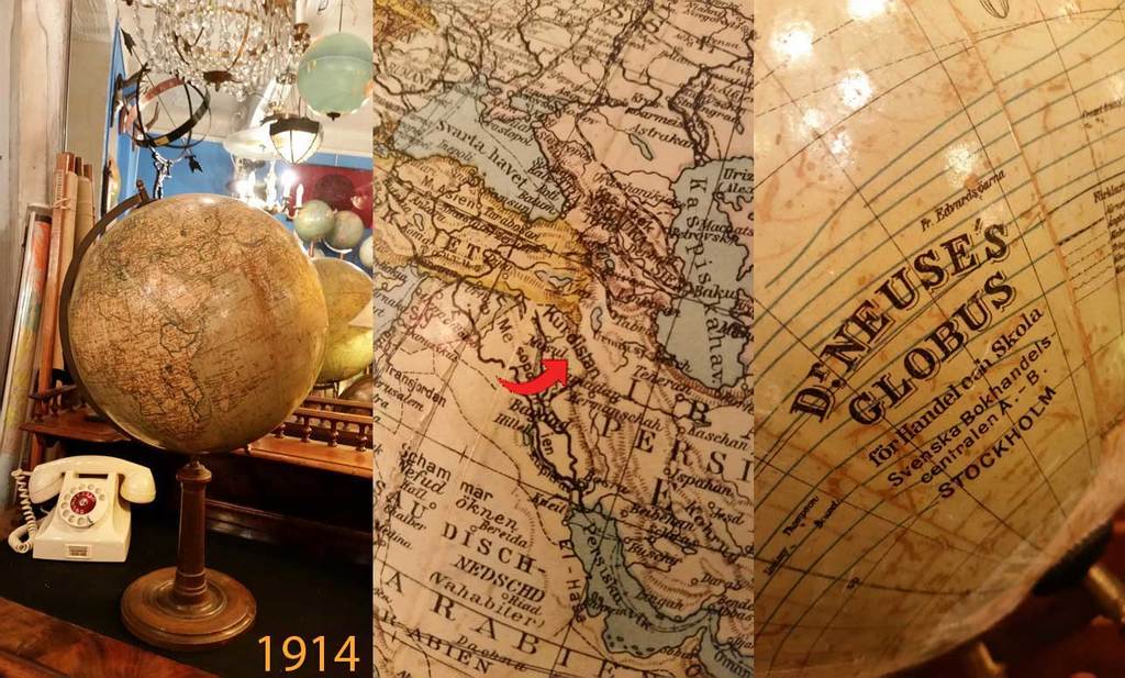
KURDISTAN'S MAPS ON THE GLOBES
Foundation For Kurdish
Library & Museum
